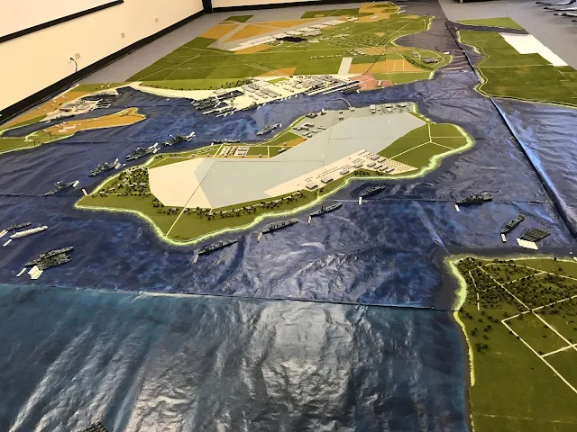
Each year about this time (decided by the U.S. History classes and when they begin covering WWII) I travel to Green Mountain High School where I taught for 24 years, located in Lakewood Colorado. I will spend 80 minutes in each of seven classes over two days, to share the incredible individual stories of those who experienced that "Day of Infamy". With the diorama, visual images, music, and the aforementioned stories, I have tried to bring this story to life for every Sophomore that year.
You will notice some areas that have not completed. While not critical to the presentation, I know I will strife to fill in those small pieces. So here it is:
Largest view could get. It misses the US CL Phoenix, Destroyer Tenders and DD to the left corner. Hickam is seen at top. Ford Island dominating the center with the Navy Yard just above it and Cincpac and the Sub Base to the left of it. The entrance channel leading to the Pacific is in upper right.
Close up of Ford Island from west with Navy Yard to the upper right. Battleship Row is to the top of the Island with US Arizona is second from left of that Row.
The Navy Yard right of center, with the Navy's PBY scout planes defenseless on the tarmac at the tip of Ford Island.
Shifting slightly southward towards Hospital Point (right/center) and the Navy Hospital (large grey building).
Centered now on Hickam Army Air Base. The large grey building is the Hale Kalai, largest military structure in the world in 1941. Still standing today, it was a 3000-man barracks just completed in 1941 for the Air Corps. The Flight Line (in light grey) is packed with the bombers that General Short ordered parked wingtip to wingtip to prevent sabotage! Easy targets they soon became!
The entrance to the harbor is just off to the right of this photo, where the anti-submarined nets were located.
Closeup of that Flight Line.
